Day 13 started out pretty early. We were on the road by 6 a.m. Not a whole lot of news to tell. EXCEPT, Lou and Bill had a "bright" idea (we're not sure they are the brightest bulbs in this motor home) to drive through the night so we could make it home late Friday night.
We made it through the night. Where did we all "sleep?" Well, Lou slept while driving with Denise beside him, Brenda on the easy chair, Bill on the sofa and me on the table (no, I was not dancing). Lou made the table into a bed. Then Lou and Bill traded places and Dee and I traded places. Stopped for a bite to eat at a truck stop while we got gas. We're on the road again with about 453 miles to go (probably about 8 hours).
This is probably my last post on this trip. My juice is running low on the computer since we haven't been anywhere to plug me in.
Bill and I need to say some thanks before I leave. Thanks to God for such a wonderful world he's created. Thanks to Lou and Dee for their hospitality. We wouldn't have been able to see as much, nor would it have been as much fun. Thanks to Brenda for her wit and smart-ass comments. I admire that in a woman. She kept us going.
So, til our next trip. See you in PA!
Wednesday, September 17, 2008
Day 12 - Arches & Canyonlands
Today, Peg had a "great" idea. She decided they would ride to Moab while Lou and Denise and Brenda rode the motorhome up. It was really cold and a huge black cloud was right in front of them as they were riding. Today was definitely an electric gloves and chaps day. The black cloud never gave us more than a few spits and spurts of rain and as we rode farther, we got closer to the blue skies and rocks. On the way to Moab, we decided to ride into the Canyonlands. What a beautiful curvy ride through the canyon and across a mesa. However, it was 34 miles in to the Visitor Center and we decided we didn't have enough time to ride any further but before we left, we decided to get gas @ $6.00/gal. We each got one gallon which would get us into Moab to our campground.
We checked into the campground and found that Lou, Denise & Brenda had already left for a ride so we decided to go on into Arches National Park. Arches National Park preserves over 2,000 natural sandstone arches, like the world-famous Delicate Arch, as well as many other unusual rock formations. In some areas, the forces of nature have exposed millions of years of geologic history. The extraordinary features of the park create a
  landscape of contrasting colors, landforms and textures that is unlike any other in the world. To really see the arches we needed to take some hikes. We saw some people high above us underneath one of the arches and we wondered how they got
  there. We found a trail that lead to that spot. Absolutely beautiful. Well, worth the hike.
We checked into the campground and found that Lou, Denise & Brenda had already left for a
 ride so we decided to go on into Arches National Park. Arches National Park preserves over 2,000 natural sandstone arches, like the world-famous Delicate Arch, as well as many other unusual rock formations. In some areas, the forces of nature have exposed millions of years of geologic history. The extraordinary features of the park create a
  landscape of contrasting colors, landforms and textures that is unlike any other in the world. To really see the arches we needed to take some hikes. We saw some people high above us underneath one of the arches and we wondered how they got
  there. We found a trail that lead to that spot. Absolutely beautiful. Well, worth the hike.
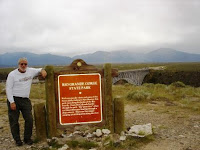
Lou, Denise & Brenda rode River Road along the Colorado River. Brenda said that was one of the most beautiful rides. Then they tried to enter the north end of Canyonlands but they were tarring and chipping the rode so they turned around. They ended up in Dead Horse Point State Park. Dead Horse Point State Park is perhaps Utah's most spectacular state park. Dead Horse Point is a promontory of stone surrounded by steep cliffs. The overlook at Dead Horse Point is 6,000 feet above sea level. Two thousand feet below, the Colorado River winds its way from the continental divide in Colorado to the Gulf of California, a distance of 1,400 miles. If you want to read more about Dead Horse Point State Park, click here
Before they came back to the campground, they rode around Arches National Park. Denise said even though they rode the same road in and out, the scenery was completely different because of the setting sun.
Tomorrow we start heading back east. We want to see you all but yet we don't want this wonderful trip to end.
Need to stop blogging for now. Lou & Bill want to leave by 6 a.m.!!! Will add pictures as we're heading down the highway.
Tuesday, September 16, 2008
Day 11 - Ride to Natural Bridges
 Can it can get any better than this? I think we've said that every day and it just keeps getting better. Today we started off for Natural Bridges Monument National Park. Natural Bridges preserves some of the finest examples of natural stone architecture in the southwest. On a tree-covered mesa next to deep sandstone canyons, three natural bridges formed when meandering streams slowly cut through the canyon walls. In honor of the Native Americans that made this area their home, the bridges are named "Kachina," "Owachomo" and "Sipapu." We ate our lunch overlooking the Sipapu Natural Bridge.
 Then Bill and I decided we wanted to hike down in the canyon to see the Sipapu bridge,  while Lou, Denise & Bren decided they wanted to ride Lake Powell, Utah, to ride across the Colorado River. Denise reports they rode for many, many, many (you get the picture) miles before seeing another human or animal. Lou said that every turn was a different picture. The one gas station they stopped at had NO attendant. You had to pay the pump, credit card only and it was $4.79/gal.
 while Lou, Denise & Bren decided they wanted to ride Lake Powell, Utah, to ride across the Colorado River. Denise reports they rode for many, many, many (you get the picture) miles before seeing another human or animal. Lou said that every turn was a different picture. The one gas station they stopped at had NO attendant. You had to pay the pump, credit card only and it was $4.79/gal.
Bill and Peg had some more awesome views as they hiked down the Sipapu Bridge trail. A moderately strenuous trail descending from the parking area along Bridge View Drive to the base of the bridge. The trail has ladders, stairs, switchbacks, and short steep sections of slickrock along its route. Sipapu is the largest and most spectacular of the three bridges in the Monument. It is considered middle aged, older than Kachina but younger than Owachomo. Its rounded opening and smooth sides are mute evidence of countless floods bearing scouring rocks and sand. This bridge, whose opening would almost house the dome of the United States Capitol, has taken thousands of years to form but will someday collapse and erode as part of the endless cycles of time and change.
We also hiked to see the Horsecollar Ruins. The Horsecollar Ruin Site is one of the best- preserved ancestral Puebloan sites in the area. Named because the doorways to two structures resemble horsecollars, the site was abandoned more than 700 years ago. Its remarkable state of preservation, including an undisturbed kiva with the original roof and interior, is likely due to the isolation of Natural Bridges: few visitors ever made the journey down these canyons.
 preserved ancestral Puebloan sites in the area. Named because the doorways to two structures resemble horsecollars, the site was abandoned more than 700 years ago. Its remarkable state of preservation, including an undisturbed kiva with the original roof and interior, is likely due to the isolation of Natural Bridges: few visitors ever made the journey down these canyons.
The next small hike we took was to see the Owachomo Bridge. Owachomo is the smallest and thinnest of the three natural bridges and is commonly thought to be the oldest. We may never know for certain, as each of the bridges certainly have eroded at different rates. Regardless of its relative age, it is certainly the most fragile and elegant of the three spans, and an awe inspiring feature of erosion.
Then, as luck would have it, while Bill and I stopped for gas, who pulled in for gas but Lou, Denise & Brenda. We decided we need to make a grocery store run. Remember, there aren't any Walmarts in the area. So we drove about 3 miles and found a "small" grocery store. We won't starve from now til we get home.
Tomorrow, we pull up the jacks and head for Moab, Utah. We want to see Arches National Park. Talk to you tomorrow.
Monday, September 15, 2008
Day 10 - Mesa Verde
Today was the second day in a row that we rode in 4 different states. We started out in Bluff, Utah, and headed east to Mesa Verde, Colorado, then from there we rode into Farmington, New Mexico, and Teec Nos Pos, Arizona.
Mesa Verde was so much more than we ever expected. Just the ride through the National Park was awesome in itself but then the tour through the pueblo ruins was incredible. The ride had those curves that only a motorcylist could love. A visit to Balcony House provides an inside look at a classic 13th century cliff dwelling. This is one of the best preserved sites in the park. It affords a stunning view down into Soda Canyon, a tributary of the Mancos River, and displays intriguing architectural features - balconies, a long retaining wall, and a tunnel.
The builders of Balcony House were people now known as Ancestral Puebloans. They were farmers, who grew crops on the mesa tops but who chose to build their homes in the cliffs during the final century of their occupation of Mesa Verde from A.D. 1200 to 1300. I wonder if our homes will survive like the pueblo ruins have for over 800 years. It was amazing there were so many cliff dwellings. They were all over the place. There were over 40,000 Ancestral Puebloans inhabitants.
We ate a picnic lunch in the park. Louie ran around trying to get a picture of a bird and Peg crawled in a tree hut. Everyone else was somewhat normal.
Mesa Verde, Spanish for green table, offers a spectacular look into the lives of the Ancestral Pueblo people who made it their home for over 700 years, from A.D. 600 to A.D. 1300. Today, the park protects over 4,000 known archeological sites, including 600 cliff dwellings. These sites are some of the most notable and best preserved in the United States.
After we were finished at Mesa Verde, we had a Tribal Council to decide what route we were going to take back to the campground. It was decided we would travel east to Durango BUT we saw black rain clouds so we made a quick turn south heading to Farmington, NM. Another beautiful ride with spectacular views.
Sunday, September 14, 2008
Day 9 - Bluff, UT
We're packing up to leave for Bluff, Utah. It's about 35 degrees outside again and 48 degrees in the motor home. But if it's like yesterday, it will warm up pretty quickly.
Talk to you in Utah.
Wish I had a video camera on my helmet. The views are absolutely breathtaking. We arrived at the Cadillac Ranch Campground in Bluff, Utah, around 1 p.m. Bill and Peg are staying at the Mokee Motel (sounds hokey, doesn't it, V-Tech fans?). I know why it's called Bluff, Utah. We have bluffs to our backs, to our sides, and to our fronts. The sun is shining so bright, bringing out all the different colors. It is desolate as Bren is writing to Aunt Lois. Not much cell signal.
Almost immediately, we took off on a ride to Four Corners. If I thought it couldn't get any better ... it did. The colors are spectacular. Four Corners is a small spot on the map in Navajo Nation country. It's the only place in the US where 4 states come together: New Mexico, Arizona, Colorado & Utah. We each put our feet in a state, had our picture taken and then we went shopping at the outside "mall." Gorgeous pottery, jewelry, sand pictures, and fry bread. I've finally moved Brenda & Dee to the darkside. They both purchased something. Yahooooo,
 I"m still the one with the shopping addiction, though.
The ride back to the campground was as beautiful as the ride to Four Corners. We saw wild mustangs and long stretches of absolutely NOTHING but prairies and bluffs. Oh, yeah, we were always on the lookout for gas stations for Brenda. They are very few and far between.
Talk to you in Utah.
Wish I had a video camera on my helmet. The views are absolutely breathtaking. We arrived
 at the Cadillac Ranch Campground in Bluff, Utah, around 1 p.m. Bill and Peg are staying at the Mokee Motel (sounds hokey, doesn't it, V-Tech fans?). I know why it's called Bluff, Utah. We have bluffs to our backs, to our sides, and to our fronts. The sun is shining so bright, bringing out all the different colors. It is desolate as Bren is writing to Aunt Lois. Not much cell signal.
 Almost immediately, we took off on a ride to Four Corners. If I thought it couldn't get any better ... it did. The colors are spectacular. Four Corners is a small spot on the map in Navajo Nation country. It's the only place in the US where 4 states come together: New Mexico,
 Arizona, Colorado & Utah. We each put our feet in a state, had our picture taken and then we went shopping at the outside "mall." Gorgeous pottery, jewelry, sand pictures, and fry bread. I've finally moved Brenda & Dee to the darkside. They both purchased something. Yahooooo,
 I"m still the one with the shopping addiction, though.
 The ride back to the campground was as beautiful as the ride to Four Corners.
 We saw wild mustangs and long stretches of absolutely NOTHING but prairies and bluffs. Oh, yeah, we were always on the lookout for gas stations for Brenda. They are very few and far between.
As the moon sets over the bluff, Louie and Bill cooked hot dogs for us. Talk to you tomorrow after we ride to Mesa Verde.

Saturday, September 13, 2008
Day 8 - Grand Canyon
Well, what to my wondering eyes should appear .... FROST! It was 35 degrees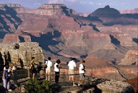 when we woke up about 6 a.m. We wanted to get an early start to the Grand Canyon but some wimps (who shall remained unnamed) want to wait until it gets a tad warmer. So, I have some time to post and read email.

 when we woke up about 6 a.m. We wanted to get an early start to the Grand Canyon but some wimps (who shall remained unnamed) want to wait until it gets a tad warmer. So, I have some time to post and read email.
Here's a little info about the Grand Canyon. A powerful and inspiring landscape, the Grand Canyon overwhelms our senses through its immense size; 277 river miles (446km) long, up to 18 miles (29km) wide, and a mile (1.6km) deep.
Stay tuned for more pics later tonight.

We're back from our ride to the Grand Canyon South Rim. This is the 2nd time Bill and I have been here and it's still awesome and splendid and all those adjectives. We had a beautiful blue skies day. We parked outside of the park and took the shuttle in to the Grand Canyon. We decided to split up because we wanted to 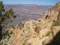 do a little hiking. So after this picture, we headed to the east portion of the South Rim to hike the Rim Trail to Yavapai Observation Station, Mather Point and Kaibab Trail. We decided to hike down into the Canyon. It was pretty easy going down but the climb back up was a killer. BUT, the vistas were worth every huff and puff (and there were plenty of them). I couldn't believe that we were down in the canyon.
 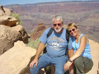 Can you find the trail?
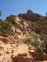
 do a little hiking. So after this picture, we headed to the east portion of the South Rim to hike the Rim Trail to Yavapai Observation Station, Mather Point and Kaibab Trail. We decided to hike down into the Canyon. It was pretty easy going down but the climb back up was a killer. BUT, the vistas were worth every huff and puff (and there were plenty of them). I couldn't believe that we were down in the canyon.
  Can you find the trail?
Tomorrow we head to Bluff, Utah. I think I"ll be resting in the motor home. Talk to you all later.
Friday, September 12, 2008
Day 7 - Heading to Williams, AZ
 This will be the last post from Albuquerque, New Mexico. We're going to start to head west to Arizona and the Grand Canyon. Hope that we have bluer skies than we do so far. It's cloudy here but NOT raining so I'm not complaining too much.
Dee just gave me some of her photos and I really need to share this one of Brenda and her new bluetooth.
As we're tooling down the highway, Dee & I are going to work on a slide show. I think I can add a flickr slideshow widget to this blog. Next time you read, there may be more pics. Catch you later.
We rode across I-40 out of New Mexico and into Arizona. I did work on a Flickr slideshow but haven't got it quite ready for you yet. Hope to have it ready before we get home :-)

Even in the motor home, it was a spectaular ride. Lots more trees in Arizona. Arrived inWilliams, AZ, got the bikes off the trailer and headed into Williams.
In case you didn't remember, it's Dee's birthday so we took her to eat at Pauncho McGillicuddy's. Can you believe that??? She had her steak, a little taste of salsa and then she had Creme Brulee for desert and the whole place sang to her. Here are some pics of that little soiree


We walked around town. Williams is located in the heart of the Kaibab National Forest at an elevation of 6,770 feet. Founded in 1880, Williams was named for the famous trapper, scout and mountain man, "Old Bill Williams." A statue of "Old Bill" can be visited at Monument Park, located on the west side of the city. The large mountain directly south of town is named Bill Williams Mountain.
Also known as the "Gateway to the Grand Canyon®," Williams was the last town in America on Historic Route 66 to be bypassed by Interstate 40. The community, bypassed on Oct. 13, 1984, continues to thrive on tourism.


That's it for Day 7. We're headed to the Grand Canyon tomorrow.
Day 6 - Albuquerque, Sante Fe and Taos & Sandia Tramway
Well, it's 10:30 again but at least everyone is talking tonight (which was definitely NOT true last night).
Here's what happened today. Lou was working on Brenda's bike early a.m. Bill and Peg decided to head up to Taos via the High Road to Taos scenic highway. Lou, Denise, and Brenda were going to meet them up there. The High Road to Taos was a beautiful ride, although it was cloudy all the way and chilly.
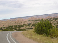 We saw lots of mountain, rocks and some houses. Every time we asked ourselves, "What do these people do for a living?" But there were schools in these remote places so they must be doing something.
When we got to Taos, we decided to go directly to the Taos Pueblo. Unfortunately, they had a death in the family so no one was allowed to enter the Pueblo. Taos Pueblo is the only living Native American community designated both a World Heritage Site by UNESCO and a National Historic Landmark. The multi-storied adobe buildings have been continuously inhabited for over 1000 years. So Peg decided they will need to return next year to visit the Taos Pueblo.
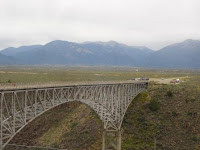
While in Taos, we walked around the plaza (Peg shopped around the Plaza). Lin, I got to go to the one quilt shop in Taos!!~ Next, we road to the Rio Grande Gorge. Although still very cloudy and misting a little, the gorge was something to view. The Rio Grande Gorge runs from northwest to southeast of Taos. The gorge depth is 800 feet just south of the Gorge Bridge, which spans the gorge ten miles northwest of Taos.
We were going to continue on to the Enchanted Circle but since you could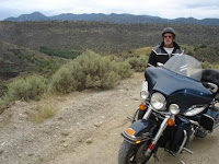 tell that it was raining in that direction, we decided to head back to Albuquerque and see what the rest were doing. As we were heading back, we passed a "little" road that Linda and Peg had been on when they visited New Mexico last year. The road isn't always open due to snow or flooding but it was open and since Peg and Linda had such a heart stopping experience on that road, Peg decided she needed to show Bill. This is a road that makes it possible for folks to get from the east side of the Rio Grande Gorge to the west side. Now, you aren't going to make any speed records and you probably won't get a speeding ticket but you will see views that those who won't make the trip will never see. Our pictures don't do it justice so you'll just have to drive out here and take the trip.
We arrived back at the campground. I had just taken off my road-weary boots when Brenda says, hey we're going to the tram, do you want to go. Sure we said, so back on went those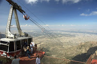 boots and away we went. The Sandia Tramway is the world’s longest aerial tramway that transports you above deep canyons and breathtaking terrain a distance of 2.7 miles. Our vantage point from the observation deck atop 10,378 foot Sandia Peak in the Cibola National Forest gave us an 11,000 square-mile panoramic view of the Rio Grande Valley and the Land of Enchantment. Remember, we were there at night so we saw the expansive view of Albuquerque lights.


That's all for tonight, folks. My eyes are starting to really hurt. Dee and I will add more tomorrow while we're cruising to Arizona and the Grand Canyon. Pray for blue skies, please.
Here's what happened today. Lou was working on Brenda's bike early a.m. Bill and Peg decided to head up to Taos via the High Road to Taos scenic highway. Lou, Denise, and Brenda were going to meet them up there. The High Road to Taos was a beautiful ride, although it was cloudy all the way and chilly.
We saw lots of mountain, rocks and some houses. Every time we asked ourselves, "What do these people do for a living?" But there were schools in these remote places so they must be doing something. When we got to Taos, we decided to go directly to the Taos Pueblo. Unfortunately, they had a death in the family so no one was allowed to enter the Pueblo. Taos Pueblo is the only living Native American community designated both a World Heritage Site by UNESCO and a National Historic Landmark. The multi-storied adobe buildings have been continuously inhabited for over 1000 years. So Peg decided they will need to return next year to visit the Taos Pueblo.
While in Taos, we walked around the plaza (Peg shopped around the Plaza). Lin, I got to go to the one quilt shop in Taos!!~ Next, we road to the Rio Grande Gorge. Although still very cloudy and misting a little, the gorge was something to view. The Rio Grande Gorge runs from northwest to southeast of Taos. The gorge depth is 800 feet just south of the Gorge Bridge, which spans the gorge ten miles northwest of Taos.


We were going to continue on to the Enchanted Circle but since you could
 tell that it was raining in that direction, we decided to head back to Albuquerque and see what the rest were doing. As we were heading back, we passed a "little" road that Linda and Peg had been on when they visited New Mexico last year. The road isn't always open due to snow or flooding but it was open and since Peg and Linda had such a heart stopping experience on that road, Peg decided she needed to show Bill. This is a road that makes it possible for folks to get from the east side of the Rio Grande Gorge to the west side. Now, you aren't going to make any speed records and you probably won't get a speeding ticket but you will see views that those who won't make the trip will never see. Our pictures don't do it justice so you'll just have to drive out here and take the trip.
We arrived back at the campground. I had just taken off my road-weary boots when Brenda says, hey we're going to the tram, do you want to go. Sure we said, so back on went those
 boots and away we went. The Sandia Tramway is the world’s longest aerial tramway that transports you above deep canyons and breathtaking terrain a distance of 2.7 miles. Our vantage point from the observation deck atop 10,378 foot Sandia Peak in the Cibola National Forest gave us an 11,000 square-mile panoramic view of the Rio Grande Valley and the Land of Enchantment. Remember, we were there at night so we saw the expansive view of Albuquerque lights.
 That's all for tonight, folks. My eyes are starting to really hurt. Dee and I will add more tomorrow while we're cruising to Arizona and the Grand Canyon. Pray for blue skies, please.
Wednesday, September 10, 2008
Day 5 - Turquoise Trail to Santa Fe and BEYOND
Sunny, blue skies and t-shirts -- we're off on the Turquoise Trail to Santa Fe. Catch you later tonight.
Sorry I didn't post last night. Keep reading to find out why.
We did make it up the Turquoise Trail which goes through the "town" of Madrid (pronounced MAD' rid). Those of you who watched Wild Hogs might know that the movie was filmed in part in that town. It's a little mountain town full of artisans. We had a great time looking at all the turquoise and Mexican pottery, hand-made chaps, etc. Then on the road again to Santa Fe.
Unfortunately, when we got there, Bren was having some problems with her bike so we stopped at the Harley Shop there. They were able to work on her bike yet that day so Lou, Denise & Bren stayed there and had lunch. Bill and I went into the Plaza in Santa Fe for lunch. Santa Fe, which means "Holy Faith," was founded in 1607 (the second oldest town in the U.S.) and joined the United States of America in 1912. The full name of our city, the location of New Mexico's state capitol, is "La Villa Real de la Santa Fe de San Francisco de Asis," or "The Royal City of the Holy Faith of Saint Francis of Assisi." We also stopped at the Capitol Building which is shaped in the state' Zia sun symbol and nicknamed Round House. The Capitol is security free which just blows my mind. It houses an extensive art collection. Next we stopped at the Loretto Chapel and its famous "miraculous" staircase. Two mysteries surround the spiral staircase in the Loretto Chapel: the identity of its builder and the physics of its construction. To read more, click this link . Sorry I can't post pics. I forgot to take my camera yesterday.
Brenda's bike was finished so we road back to the Harley Shop to meet them. Now comes the part about why I didn't post last night. Bill decided to take us on a ride since we didn't get much riding in yesterday. He took us to Las Vegas (no not the Nevada Las Vegas) and then from there up the High Road to Taos. Proably was a beautiful ride but it was getting dark by then, a little rainy AND freezing cold to those of us not on the luxury bikes! After the High Road to Taos, we had to ride back down (2.5 hours) to Albuquerque. We pulled into the campground at 10:30 p.m.!! I know this will become a cherished memory at some point BUT NOT FOR A LONG WHILE!!
Well, we're up and ready for another one though, so call me stupid but here I go again. We're going to head back up the High Road (maybe this time we'll be able to see and appreciate it's beauty) to Taos. We want to visit the Taos Pueblo. More on that tonight (or will it be tomorrow morning). We shall see. Catch you later
Tuesday, September 9, 2008
Day 4 - Jemez Trail & Bandelier Nat'l Monument
Well, the decision of the day is where will we ride. The boys are discussing. More to follow. First, though, is breakfast. At this KOA campground, they provide pancakes with green chille sauce. That's where I"m going now.
Weather is beautiful but chilly at 8:30 a.m. The weather report said there wa 40% chance of rain though. We decided to ride the Jemez Mountain Trail (pronounced HAY-mez) to Bandelier National Monument. What a beautiful ride. The Jemez Mountain Trail takes you past amazing geological formations, ancient Indian ruins, an Indian pueblo, and the remainders of the area's logging, mining and ranching heritage.

On the Jemez Mountain Trail, we stopped to see Soda Dam. A very deep fault at Soda Dam (roughly perpendicular to the highway) serves as a conduit to bring water to the surface. Because of deep faults in the area, surface waters are able to penetrate deep enough to be heated by the earth itself, which is in turn heated by the molten rock underlying the area. Heated and pressurized water carries gases and minerals in a dissolved form to the surface, just like "hard water deposits" in a home faucet.
Soda Dam forms a natural dam to the Jemez River, which cuts through it to continue its course. The unique formation shows the continuous processes of nature both building and destroying the feature at the same time.


On the way back we saw rain clouds, dark rain clouds. Louie heard that 1/2 inch hail was in the town of Madrid so we decided not to travel the Turquoise Trail which would go through Madrid. We'll do that tomorrow. We took I-25 back to the campground. We dodged another rain bullet. More tomorrow.
Weather is beautiful but chilly at 8:30 a.m. The weather report said there wa 40% chance of rain though. We decided to ride the Jemez Mountain Trail (pronounced HAY-mez) to Bandelier National Monument. What a beautiful ride. The Jemez Mountain Trail takes you past amazing geological formations, ancient Indian ruins, an Indian pueblo, and the remainders of the area's logging, mining and ranching heritage.
On the Jemez Mountain Trail, we stopped to see Soda Dam. A very deep fault at Soda Dam (roughly perpendicular to the highway) serves as a conduit to bring water to the surface. Because of deep faults in the area, surface waters are able to penetrate deep enough to be heated by the earth itself, which is in turn heated by the molten rock underlying the area. Heated and pressurized water carries gases and minerals in a dissolved form to the surface, just like "hard water deposits" in a home faucet.
Soda Dam forms a natural dam to the Jemez River, which cuts through it to continue its course. The unique formation shows the continuous processes of nature both building and destroying the feature at the same time.
Also along Rt 4 on the Jemez Mountain Trail was another photo op - Battleship Rock.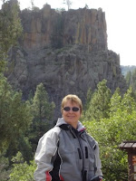
On to Bandelier National Monument. Bandelier has a long human history and links to the modern Pueblos. Traditions which began in the distant past are still practiced today. At Bandelier, evidence of the Ancestral Pueblo people can be found in the dwellings, artifacts, and continuing culture of the modern pueblos. We walked the 1.2 mile trail and visited the Alcove House with its 140 foot ascent on 4 wooden ladders and many stone stairs.
On the way back we saw rain clouds, dark rain clouds. Louie heard that 1/2 inch hail was in the town of Madrid so we decided not to travel the Turquoise Trail which would go through Madrid. We'll do that tomorrow. We took I-25 back to the campground. We dodged another rain bullet. More tomorrow.
Monday, September 8, 2008
Day 3 - leaving from Texas
Since we had such a late night (didn't arrive at the campground until 8:30 p.m.), we decided that we wouldn't rush around in the a.m. Got on the road at 9:10 a.m.. The Princess says we have about 300 miles until we reach Albuquerque. Hopefully we'll be riding by late afternoon. It's cloudy, which is perfect for driving in the motor home. For those of you who don't know what our home away from home looks like, here it is, all 63'.

Edith wanted to know what scenery is passing. Here's a picture of the alternative energy windmills we saw in Oklahoma. As I see more to take, I'll keep adding. You keep reading
Well, it was a long haul across Texas and halfway into New Mexico. Thought we'd never get there. It got a lot more hilly as we made our way to Albuquerque. But, we made it (and so did the bikes). In fact, we're getting ready to ride somewhere. Will post more tonight (with pics).
Since the boys were couldn't wait to get on the road with the bikes, we didn't take as much time as we should have to look at a map. In fact, we didn't even look at a map, did we?? Some guy at the campground mentioned that we should ride up Rt 550 to some pueblos, so off we went. As we kept going, there was a HUGE black cloud over us and was quite windy. Fortunately, we didn't get too much rain. Just enough to make us stop and put our rain gear on. Unfortunately, Brenda's bike was acting up, coughing and sputtering. So we decided we better get back to the campground so that the SL Shuff Garage (that's Stanley Lewis Shuffstall Garage) could take a look at her.
Lou worked on Bren's bike and then they took a short ride to see if his work paid off. Peg and BIll road to a Mexican restaurant that Peg ate at when she was here last year for her conference. Then they road to Old Town Albuquerque and walked around.
Lou thinks that Bren's bike doesn't like the altitude here in NM.We'll see how she works when we make our way on several trails tomorrow. More on that tomorrow.
The picture with the 4 yahoos is the cabin that Bill & Peg stay in while Lou, Denise & Bren stay in the motor home.
In the background of Bill's picture are the Sandia Mountains.
 that we wouldn't rush around in the a.m. Got on the road at 9:10 a.m.. The Princess says we have about 300 miles until we reach Albuquerque. Hopefully we'll be riding by late afternoon. It's cloudy, which is perfect for driving in the motor home. For those of you who don't know what our home away from home looks like, here it is, all 63'.
Edith wanted to know what scenery is passing. Here's a picture of the alternative energy windmills we saw in Oklahoma. As I see more to take, I'll keep adding. You keep reading
Well, it was a long haul across Texas and halfway into New Mexico. Thought we'd never get there. It got a lot more hilly as we made our way to Albuquerque. But, we made it (and so did the bikes). In fact, we're getting ready to ride somewhere. Will post more tonight (with pics).
Since the boys were couldn't wait to get on the road with the bikes, we didn't take as much
time as we should have to look at a map. In fact, we didn't even look at a map, did we?? Some guy at the campground mentioned that we should ride up Rt 550 to some pueblos, so off we went. As we kept going, there was a HUGE black cloud over us and was quite windy. Fortunately, we didn't get too much rain. Just enough to make us stop and put our rain gear on. Unfortunately, Brenda's bike was acting up, coughing and sputtering. So we decided we better get back to the campground so that the SL Shuff Garage (that's Stanley Lewis Shuffstall Garage) could take a look at her.Lou worked on Bren's bike and then they took a short ride to see if his work paid off. Peg and BIll road to a Mexican restaurant that Peg ate at when she was here last year for her conference. Then they road to Old Town Albuquerque and walked around.
Lou thinks that Bren's bike doesn't like the altitude here in NM.We'll see how she works when we make our way on several trails tomorrow. More on that tomorrow.
The picture with the 4 yahoos is the cabin that Bill & Peg stay in while Lou, Denise & Bren
 stay in the motor home.
In the background of Bill's picture are the Sandia Mountains.

Sunday, September 7, 2008
Day 2 - Sept 7, 2008


From Meramec, MO, we travelled through Oklahoma. It was overcast for the morning but then the afternoon warmed up considerably. Peg needed some thread to work on one of her quilting projects, so wonderful bro-in-law, Louie, stopped at a Walmart so I could pick up thread and anything else we just had to have. We ate lunch in the parking Walmart parking lot, got gas, and then on the road again. I began working on my 2nd quilt project, Dee is reading, Brenda was reading (and napping)
Do you realize how large Oklahoma is? Ask Bill and Lou. They drove it, taking turns being pilot and co-pilot with the help of Princess (Dee's GPS). The princess got a little nervous when she thought Bill had gone off road in the motor home!! Guess that portion of the road was new. The princess had some heavy breathing until she finally found the road again. Well, now we're heading to Texas. Brenda told us why it's so hot in the motor home -- it's 103 outside!
Do you realize how large Oklahoma is? Ask Bill and Lou. They drove it, taking turns being pilot and co-pilot with the help of Princess (Dee's GPS). The princess got a little nervous when she thought Bill had gone off road in the motor home!! Guess that portion of the road was new. The princess had some heavy breathing until she finally found the road again. Well, now we're heading to Texas. Brenda told us why it's so hot in the motor home -- it's 103 outside!
It's 5:03 p.m. OK time. Lou's deciding how much farther we'll go for the day. We're just ready to cross into Texas.
BTW, have I mentioned that I've been blogging as we're going down the road. Thanks to the aircard. It's really been quite speedy.
Day 1 - Sept 6, 2008
Stanley Lewis got us up at 4 a.m. so we could be on the road by 5 a.m.!! Billl, Peg and Brenda needed coffee so they got that at Sheetz before we all crawled into the motor home. AND, we were off.
We made it to Meramec, Missouri around 6 p.m. after 700+ miles across several inter-states. We found a KOA campground. Bill and I got a cabin and the rest stayed in the motor home. After eating hamburgers, we found our way to bed quite early (remember, we've !!been up since 4 a.m.!!) BUT not after Louie telling us that we were leaving by 7 a.m. Since we knew he'd leave without us (ask Brenda about that), we set our alarms but we were up and ready to go when everyone else was ready.
We made it to Meramec, Missouri around 6 p.m. after 700+ miles across several inter-states. We found a KOA campground. Bill and I got a cabin and the rest stayed in the motor home. After eating hamburgers, we found our way to bed quite early (remember, we've !!been up since 4 a.m.!!) BUT not after Louie telling us that we were leaving by 7 a.m. Since we knew he'd leave without us (ask Brenda about that), we set our alarms but we were up and ready to go when everyone else was ready.
Getting ready
Plans have been made. Dee has been working her butt off getting all the arrangements made to stay at KOA camp grounds in New Mexico, Arizona, and Utah. Lists of groceries and clothe were sent back and forth. Again, Dee did the work gathering the grocercies. Oh, yeah, Lou got the motor home ready (with Dee's help, of course).
The day finally arrived for us to leave to meet Bill's brother and sister-in-law, Lou & Denise and cousin Brenda. Bill and I left State College, PA, around 5 p.m. and arrived at Conneaut Lake at 8 p.m. But, were our hosts at home, no, they were at Ponderosa eating!! Finally the got home and we made final plans to leave in the morning.
The day finally arrived for us to leave to meet Bill's brother and sister-in-law, Lou & Denise and cousin Brenda. Bill and I left State College, PA, around 5 p.m. and arrived at Conneaut Lake at 8 p.m. But, were our hosts at home, no, they were at Ponderosa eating!! Finally the got home and we made final plans to leave in the morning.
Subscribe to:
Posts (Atom)